


Tour de la soie à pied

audrey54
User
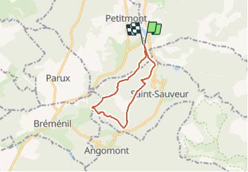

Length
9.3 km

Max alt
459 m

Uphill gradient
259 m
Km-Effort
12.7 km

Min alt
316 m

Downhill gradient
252 m
Boucle
Yes
Creation date :
2021-09-07 13:22:08.0
Updated on :
2021-09-07 15:16:04.8
1h54
Difficulty : Difficult

FREE GPS app for hiking
 SityTrail
IGN / Geographical institutes
SityTrail Plus
The world is yours!
About
Trail Walking of 9.3 km to be discovered at Grand Est, Meurthe-et-Moselle, Val-et-Châtillon. This trail is proposed by audrey54.
Positioning
Country:
France
Region :
Grand Est
Department/Province :
Meurthe-et-Moselle
Municipality :
Val-et-Châtillon
Location:
Unknown
Start:(Dec)
Start:(UTM)
349862 ; 5379496 (32U) N.
Comments