


Perses

raygautier
User
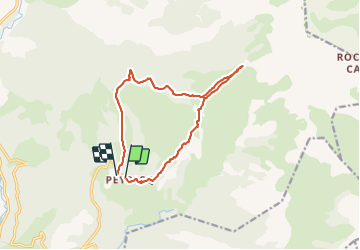

Length
13.4 km

Max alt
2088 m

Uphill gradient
655 m
Km-Effort
22 km

Min alt
1517 m

Downhill gradient
659 m
Boucle
No
Creation date :
2021-09-09 06:53:52.0
Updated on :
2021-09-09 12:58:00.931
6h03
Difficulty : Very difficult

FREE GPS app for hiking
 SityTrail
IGN / Geographical institutes
SityTrail Plus
The world is yours!
About
Trail Walking of 13.4 km to be discovered at Provence-Alpes-Côte d'Azur, Alpes-de-Haute-Provence, Thorame-Haute. This trail is proposed by raygautier.
Positioning
Country:
France
Region :
Provence-Alpes-Côte d'Azur
Department/Province :
Alpes-de-Haute-Provence
Municipality :
Thorame-Haute
Location:
Unknown
Start:(Dec)
Start:(UTM)
309120 ; 4882221 (32T) N.
Comments