


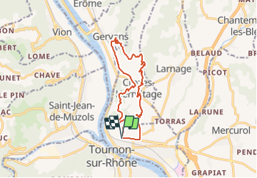
Tain 14km

thonyc
User GUIDE

Length
14 km

Max alt
339 m

Uphill gradient
510 m
Km-Effort
21 km

Min alt
119 m

Downhill gradient
512 m
Boucle
Yes
Creation date :
2021-09-09 15:06:43.86
Updated on :
2021-09-09 15:11:16.587
4h45
Difficulty : Medium

FREE GPS app for hiking
 SityTrail
IGN / Geographical institutes
SityTrail Plus
The world is yours!
About
Trail Walking of 14 km to be discovered at Auvergne-Rhône-Alpes, Drôme, Tain-l'Hermitage. This trail is proposed by thonyc.
Positioning
Country:
France
Region :
Auvergne-Rhône-Alpes
Department/Province :
Drôme
Municipality :
Tain-l'Hermitage
Location:
Unknown
Start:(Dec)
Start:(UTM)
644665 ; 4992756 (31T) N.
Comments