


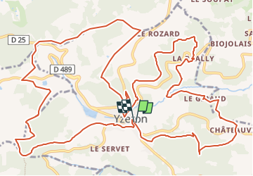
YZERON - Py Froid

JacouBrijou
User

Length
20 km

Max alt
890 m

Uphill gradient
723 m
Km-Effort
30 km

Min alt
517 m

Downhill gradient
721 m
Boucle
Yes
Creation date :
2021-09-09 20:52:57.553
Updated on :
2022-05-05 13:57:54.722
4h56
Difficulty : Very difficult

FREE GPS app for hiking
 SityTrail
IGN / Geographical institutes
SityTrail Plus
The world is yours!
About
Trail Walking of 20 km to be discovered at Auvergne-Rhône-Alpes, Rhône, Yzeron. This trail is proposed by JacouBrijou.
Description
randonnée simple autour d'Yzeron et de son lac
Positioning
Country:
France
Region :
Auvergne-Rhône-Alpes
Department/Province :
Rhône
Municipality :
Yzeron
Location:
Unknown
Start:(Dec)
Start:(UTM)
623918 ; 5062735 (31T) N.
Comments