Couches Côtes du Couchois page 44

grasgilbert
User
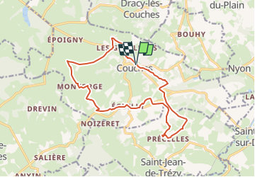

Length
15.9 km

Max alt
450 m

Uphill gradient
375 m
Km-Effort
21 km

Min alt
261 m

Downhill gradient
375 m
Boucle
Yes
Creation date :
2021-09-10 07:52:06.155
Updated on :
2024-06-06 15:46:19.405
4h45
Difficulty : Medium

FREE GPS app for hiking
 SityTrail
IGN / Geographical institutes
SityTrail Plus
The world is yours!
About
Trail On foot of 15.9 km to be discovered at Bourgogne-Franche-Comté, Saône-et-Loire, Couches. This trail is proposed by grasgilbert.
Description
mettre Waze GPS pour trouver le parking

Positioning
Country:
France
Region :
Bourgogne-Franche-Comté
Department/Province :
Saône-et-Loire
Municipality :
Couches
Location:
Unknown
Start:(Dec)
Start:(UTM)
619992 ; 5191930 (31T) N.
Comments