


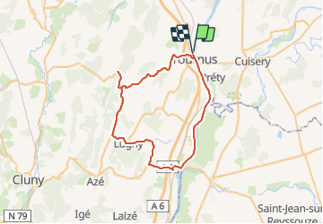
Environs de Tournus

PhilippeC54
User

Length
52 km

Max alt
373 m

Uphill gradient
586 m
Km-Effort
60 km

Min alt
166 m

Downhill gradient
585 m
Boucle
Yes
Creation date :
2021-09-10 07:25:01.967
Updated on :
2021-09-10 10:36:11.761
2h51
Difficulty : Medium

FREE GPS app for hiking
 SityTrail
IGN / Geographical institutes
SityTrail Plus
The world is yours!
About
Trail Road bike of 52 km to be discovered at Bourgogne-Franche-Comté, Saône-et-Loire, Tournus. This trail is proposed by PhilippeC54.
Positioning
Country:
France
Region :
Bourgogne-Franche-Comté
Department/Province :
Saône-et-Loire
Municipality :
Tournus
Location:
Unknown
Start:(Dec)
Start:(UTM)
646426 ; 5158862 (31T) N.
Comments