


Regalon-Majorques

MarcLEBARON
User
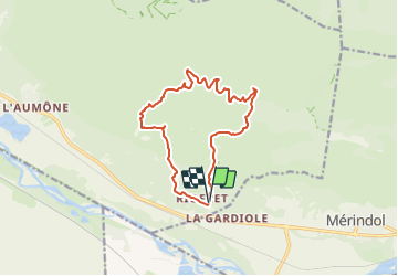

Length
13.7 km

Max alt
371 m

Uphill gradient
430 m
Km-Effort
19.4 km

Min alt
121 m

Downhill gradient
428 m
Boucle
Yes
Creation date :
2021-09-10 15:58:21.549
Updated on :
2023-12-02 15:44:37.551
4h24
Difficulty : Difficult

FREE GPS app for hiking
 SityTrail
IGN / Geographical institutes
SityTrail Plus
The world is yours!
About
Trail Walking of 13.7 km to be discovered at Provence-Alpes-Côte d'Azur, Vaucluse, Cheval-Blanc. This trail is proposed by MarcLEBARON.
Positioning
Country:
France
Region :
Provence-Alpes-Côte d'Azur
Department/Province :
Vaucluse
Municipality :
Cheval-Blanc
Location:
Unknown
Start:(Dec)
Start:(UTM)
673648 ; 4847442 (31T) N.
Comments