


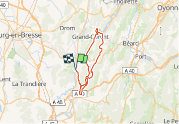
Gorges de l'Ain

PhilippeC54
User

Length
45 km

Max alt
396 m

Uphill gradient
744 m
Km-Effort
55 km

Min alt
253 m

Downhill gradient
744 m
Boucle
Yes
Creation date :
2021-09-11 07:25:03.299
Updated on :
2021-09-11 09:58:58.359
2h22
Difficulty : Easy

FREE GPS app for hiking
 SityTrail
IGN / Geographical institutes
SityTrail Plus
The world is yours!
About
Trail Road bike of 45 km to be discovered at Auvergne-Rhône-Alpes, Ain, Bohas-Meyriat-Rignat. This trail is proposed by PhilippeC54.
Positioning
Country:
France
Region :
Auvergne-Rhône-Alpes
Department/Province :
Ain
Municipality :
Bohas-Meyriat-Rignat
Location:
Meyriat
Start:(Dec)
Start:(UTM)
684695 ; 5112090 (31T) N.
Comments