


brochon grevrey

LUCIE2016
User
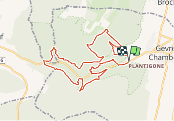

Length
11.3 km

Max alt
472 m

Uphill gradient
510 m
Km-Effort
18.1 km

Min alt
298 m

Downhill gradient
521 m
Boucle
Yes
Creation date :
2021-09-11 07:39:14.632
Updated on :
2021-09-11 13:29:05.371
5h17
Difficulty : Difficult

FREE GPS app for hiking
 SityTrail
IGN / Geographical institutes
SityTrail Plus
The world is yours!
About
Trail Walking of 11.3 km to be discovered at Bourgogne-Franche-Comté, Côte-d'Or, Gevrey-Chambertin. This trail is proposed by LUCIE2016.
Positioning
Country:
France
Region :
Bourgogne-Franche-Comté
Department/Province :
Côte-d'Or
Municipality :
Gevrey-Chambertin
Location:
Unknown
Start:(Dec)
Start:(UTM)
648102 ; 5231908 (31T) N.
Comments