


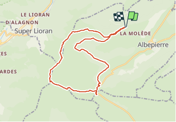
cantal col de la molede prat de bouc

jeanic63
User

Length
18.1 km

Max alt
1826 m

Uphill gradient
833 m
Km-Effort
29 km

Min alt
1305 m

Downhill gradient
834 m
Boucle
Yes
Creation date :
2021-09-11 16:53:41.126
Updated on :
2021-09-11 16:55:24.037
6h38
Difficulty : Difficult

FREE GPS app for hiking
 SityTrail
IGN / Geographical institutes
SityTrail Plus
The world is yours!
About
Trail On foot of 18.1 km to be discovered at Auvergne-Rhône-Alpes, Cantal, Albepierre-Bredons. This trail is proposed by jeanic63.
Description
départ col de la molède
Positioning
Country:
France
Region :
Auvergne-Rhône-Alpes
Department/Province :
Cantal
Municipality :
Albepierre-Bredons
Location:
Unknown
Start:(Dec)
Start:(UTM)
485382 ; 4992392 (31T) N.
Comments