Trail Walking Aime-la-Plagne - Beaufortain: Autour de La Pierra Menta: J6 - Ref. de La Coire - Pk Laval - Photo

Beaufortain: Autour de La Pierra Menta: J6 - Ref. de La Coire - Pk Laval

 patjobou
patjobou

User

© OpenStreetMap contributors
Length
Length
10.4 km
Max alt
Max alt
2274 m
Uphill gradient
Uphill gradient
290 m
Km-Effort
Km-Effort  
17 km
Min alt
Min alt
1249 m
Downhill gradient
Downhill gradient
1102 m
Boucle
Boucle
No
Creation date :
2021-09-04 06:26:38.272
Updated on :
2021-09-16 16:26:54.065

(0 Reviews)

Walking
Walking
3h21
Difficulty : Medium

Scan this QR Code to open this trail in the SityTrail application

FREE GPS app for hiking

Logo SityTrail SityTrail

IGN / Geographical institutes

Download SityTrail from the App Store Download SityTrail from Google Play

Logo SityTrail SityTrail World

The world is yours!

Download SityTrail from the App Store Download SityTrail from Google Play Download SityTrail on Huawei AppGallery

About

Trail Walking of 10.4 km to be discovered at Auvergne-Rhône-Alpes, Savoy, Aime-la-Plagne. This trail is proposed by patjobou.

Description

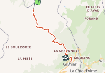
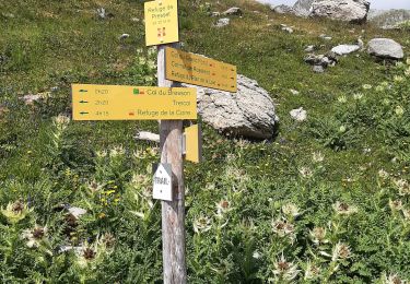
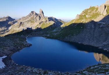
J6: Du refuge de La Coire au parking de Laval en passant par le passage de Borpas et Le Verraret.
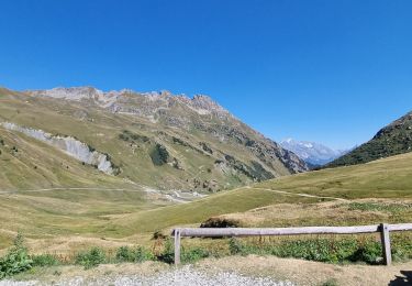
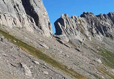
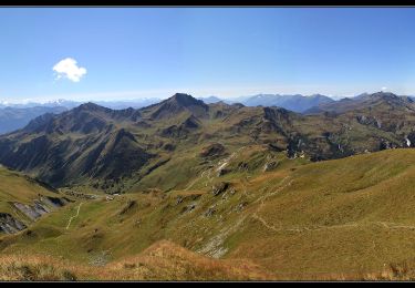
Départ 8h30 couvert, pluie annoncée pour 13h. Nous choisissons un itinéraire plus court que celui prévu par La Pointe de Combe Bénite (qui existe bien). Sur proposition du gardien, nous rejoindrons Laval par Le Passage de Borpas (2170m), superbe sentier en balcon, même pas documenté sur par l'IGN !
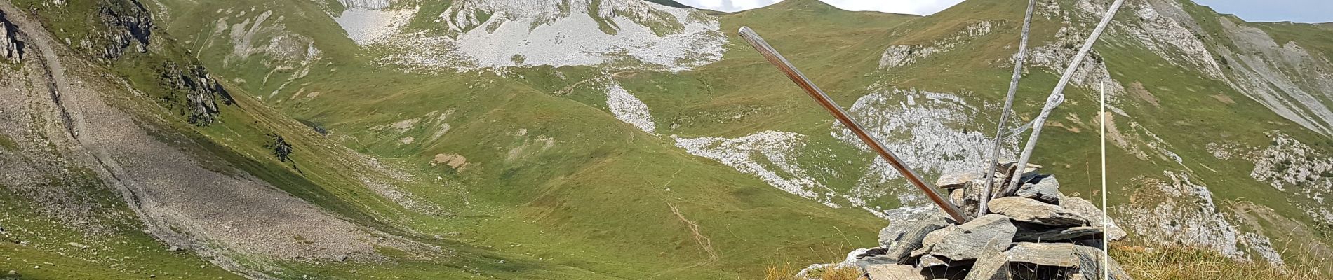
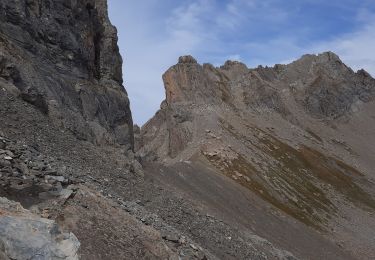
Sentier à travers les pâturages pour rejoindre le col sans nom à  2300m . Puis cabane de Pouprezaz et passage de Borpas. Superbe parcours en balcon. Repas au Verraret avant la pluie ?  Non! Nous resterons au sec pour cette dernière journée. Séparation du groupe sous le hameau (1767m):  Les chauffeurs retourneront à Laval, pour faire la manip de voiture inverse (30 mn), les piétons descendront à Granier (1h) pour les retrouver.

Elevation profile

Photos

Positioning

Country:
France
Region :
Auvergne-Rhône-Alpes
Department/Province :
Savoy
Municipality :
Aime-la-Plagne
Location:
Granier
Start:(UTM)
313519 ; 5054420 (32T) N.

Trails nearby

Trail Walking Beaufort - lac de Presset et passeur de la Mintaz (belvédère de la Pierra Menta) - Photo
Walking
GUIDE
amiral13

Walking

Difficult
Beaufort, Auvergne-Rhône-Alpes, Savoy, France
11.6 km | 24 km-effort
2h 57min
Yes
Trail Walking La Plagne-Tarentaise - Du refuge de Presset au refuge de la Coire - Photo
Walking
GUIDE
Desrumaux

Walking

Medium
La Plagne-Tarentaise, Auvergne-Rhône-Alpes, Savoy, France
9 km | 15.6 km-effort
5h 0min
No
Trail Snowshoes Aime-la-Plagne - combe benite - Photo
Snowshoes
whisper73

Snowshoes

Difficult
(1)
Aime-la-Plagne, Auvergne-Rhône-Alpes, Savoy, France
5.3 km | 16.4 km-effort
2h 56min
No
Trail Walking Beaufort - Brèche de Parozan - Photo
Walking
GuyVachet

Walking

Very difficult
Beaufort, Auvergne-Rhône-Alpes, Savoy, France
9.6 km | 23 km-effort
4h 29min
Yes
Trail Walking Aime-la-Plagne - Lac de Presset par la Piera Menta depuis le Cornet d'Arêches - Photo
Walking
tyax93

Walking

Medium
(1)
Aime-la-Plagne, Auvergne-Rhône-Alpes, Savoy, France
17 km | 32 km-effort
6h 49min
Yes
Trail Walking La Plagne-Tarentaise - BEAUFORTIN: DU REFUGE DE PRESSET A TREICOL - Photo
Walking
djeepee74

Walking

Difficult
La Plagne-Tarentaise, Auvergne-Rhône-Alpes, Savoy, France
19 km | 31 km-effort
5h 55min
No
Trail Walking Beaufort - BEAUFORTIN: DE TREICOL AU REFUGE DE PRESSET - Photo
Walking
djeepee74

Walking

Medium
Beaufort, Auvergne-Rhône-Alpes, Savoy, France
9.1 km | 19.1 km-effort
3h 10min
No
Trail Walking Aime-la-Plagne - Mont Coin  - Photo
Walking
flip38

Walking

Medium
Aime-la-Plagne, Auvergne-Rhône-Alpes, Savoy, France
17 km | 32 km-effort
6h 59min
Yes
Trail Walking La Plagne-Tarentaise - Beaufortain: Autour de La Pierra Menta: J3 - Ref de Presset - Ref du Col du Bonhomme - Photo
Walking
patjobou

Walking

Difficult
La Plagne-Tarentaise, Auvergne-Rhône-Alpes, Savoy, France
14.1 km | 26 km-effort
4h 53min
No


Close
My subscriptions