


Gaschney-les Tourbieres-lac de Schiessrothried

lemuid
User
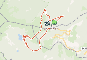

Length
8.9 km

Max alt
1152 m

Uphill gradient
325 m
Km-Effort
13.2 km

Min alt
934 m

Downhill gradient
315 m
Boucle
Yes
Creation date :
2021-09-12 11:31:14.178
Updated on :
2021-09-12 11:33:14.845
3h00
Difficulty : Easy

FREE GPS app for hiking
 SityTrail
IGN / Geographical institutes
SityTrail Plus
The world is yours!
About
Trail Walking of 8.9 km to be discovered at Grand Est, Haut-Rhin, Stosswihr. This trail is proposed by lemuid.
Positioning
Country:
France
Region :
Grand Est
Department/Province :
Haut-Rhin
Municipality :
Stosswihr
Location:
Unknown
Start:(Dec)
Start:(UTM)
354412 ; 5321990 (32U) N.
Comments