


Munster-Hohrodherg-Hohrod-Munster

lemuid
User
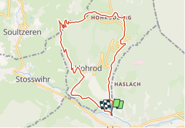

Length
9.5 km

Max alt
841 m

Uphill gradient
453 m
Km-Effort
15.6 km

Min alt
387 m

Downhill gradient
456 m
Boucle
Yes
Creation date :
2021-09-12 11:50:51.662
Updated on :
2021-09-12 11:52:31.89
3h32
Difficulty : Medium

FREE GPS app for hiking
 SityTrail
IGN / Geographical institutes
SityTrail Plus
The world is yours!
About
Trail Walking of 9.5 km to be discovered at Grand Est, Haut-Rhin, Munster. This trail is proposed by lemuid.
Positioning
Country:
France
Region :
Grand Est
Department/Province :
Haut-Rhin
Municipality :
Munster
Location:
Unknown
Start:(Dec)
Start:(UTM)
360869 ; 5322893 (32U) N.
Comments