


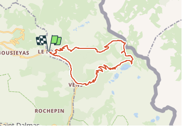
Lac de Vens depuis le Pra par le col du Fer

aris
User


8h11
Difficulty : Difficult

FREE GPS app for hiking
 SityTrail
IGN / Geographical institutes
SityTrail Plus
The world is yours!
About
Trail Walking of 19.1 km to be discovered at Provence-Alpes-Côte d'Azur, Maritime Alps, Saint-Dalmas-le-Selvage. This trail is proposed by aris.
Description
Joli parcours, la montée au col du Fer permet une incursion en Italie.
Ne pas hésiter à monter au petit sommet de l'Aiguille de Tortisse (10mn depuis le collet du même nom), la vue est spectaculaire sur les lacs de Vens.
Petit bémol : il faudra marcher environ 30mn sur la route en fin de journée pour fermer la boucle.
Positioning
Comments