


Chanier

mimosa55
User
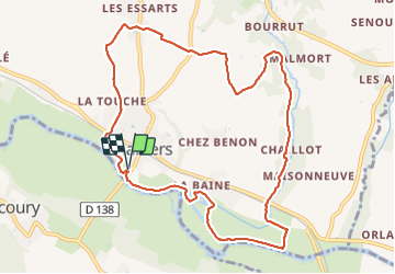

Length
10.7 km

Max alt
62 m

Uphill gradient
101 m
Km-Effort
12.1 km

Min alt
-1 m

Downhill gradient
101 m
Boucle
Yes
Creation date :
2021-09-13 12:11:17.865
Updated on :
2021-09-13 14:50:30.954
2h38
Difficulty : Difficult

FREE GPS app for hiking
 SityTrail
IGN / Geographical institutes
SityTrail Plus
The world is yours!
About
Trail Walking of 10.7 km to be discovered at New Aquitaine, Charente-Maritime, Chaniers. This trail is proposed by mimosa55.
Positioning
Country:
France
Region :
New Aquitaine
Department/Province :
Charente-Maritime
Municipality :
Chaniers
Location:
Unknown
Start:(Dec)
Start:(UTM)
689950 ; 5065359 (30T) N.
Comments