


clairlieu,-fleurion-m.for
© OpenStreetMap contributors


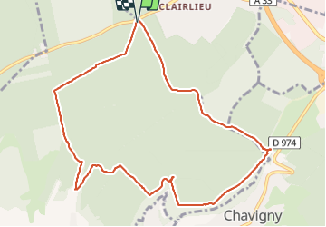
3h15
Difficulty : Very difficult


Length
10.4 km
Max alt
412 m
Uphill gradient
221 m
Km-Effort
13.3 km
Min alt
304 m
Downhill gradient
223 m
Boucle
Yes
Creation date :
2021-09-13 12:23:53.712
Updated on :
2021-09-13 17:04:47.499
3h15
Difficulty : Very difficult
FREE GPS app for hiking
 SityTrail
IGN / Geographical institutes
SityTrail Plus
The world is yours!
About
Trail Walking of 10.4 km to be discovered at Grand Est, Meurthe-et-Moselle, Chaligny. This trail is proposed by jerome-dupont@laposte.net.
Description
marche
Positioning
Country:
France
Region :
Grand Est
Department/Province :
Meurthe-et-Moselle
Municipality :
Chaligny
Location:
Unknown
Start:(Dec)
Start:(UTM)
286653 ; 5393006 (32U) N.
Comments