


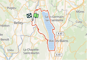
Lac du Bourget par col du Chat

PhilippeC54
User

Length
69 km

Max alt
656 m

Uphill gradient
1139 m
Km-Effort
84 km

Min alt
225 m

Downhill gradient
1140 m
Boucle
Yes
Creation date :
2021-09-14 07:05:03.374
Updated on :
2021-09-15 14:37:00.056
3h54
Difficulty : Medium

FREE GPS app for hiking
 SityTrail
IGN / Geographical institutes
SityTrail Plus
The world is yours!
About
Trail Road bike of 69 km to be discovered at Auvergne-Rhône-Alpes, Ain, Massignieu-de-Rives. This trail is proposed by PhilippeC54.
Positioning
Country:
France
Region :
Auvergne-Rhône-Alpes
Department/Province :
Ain
Municipality :
Massignieu-de-Rives
Location:
Unknown
Start:(Dec)
Start:(UTM)
715153 ; 5071941 (31T) N.
Comments