Plateau de Parian

PhilippeC54
User
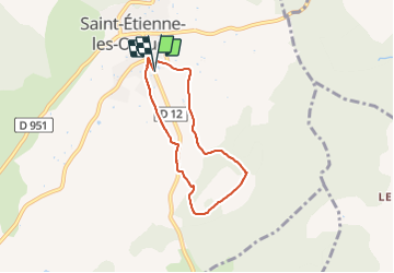

Length
5.8 km

Max alt
673 m

Uphill gradient
132 m
Km-Effort
7.6 km

Min alt
601 m

Downhill gradient
132 m
Boucle
Yes
Creation date :
2021-09-16 09:08:56.487
Updated on :
2021-09-16 10:33:56.738
1h20
Difficulty : Very easy

FREE GPS app for hiking
 SityTrail
IGN / Geographical institutes
SityTrail Plus
The world is yours!
About
Trail Walking of 5.8 km to be discovered at Provence-Alpes-Côte d'Azur, Alpes-de-Haute-Provence, Saint-Étienne-les-Orgues. This trail is proposed by PhilippeC54.
Positioning
Country:
France
Region :
Provence-Alpes-Côte d'Azur
Department/Province :
Alpes-de-Haute-Provence
Municipality :
Saint-Étienne-les-Orgues
Location:
Unknown
Start:(Dec)
Start:(UTM)
722895 ; 4880213 (31T) N.
Comments