


La Rosace des Piches

Nathy8913
User
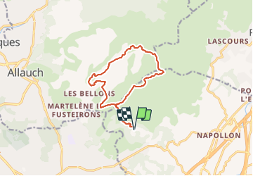

Length
13.4 km

Max alt
682 m

Uphill gradient
622 m
Km-Effort
22 km

Min alt
222 m

Downhill gradient
622 m
Boucle
Yes
Creation date :
2021-09-17 09:16:48.45
Updated on :
2021-09-17 09:21:20.397
4h56
Difficulty : Medium

FREE GPS app for hiking
 SityTrail
IGN / Geographical institutes
SityTrail Plus
The world is yours!
About
Trail Walking of 13.4 km to be discovered at Provence-Alpes-Côte d'Azur, Bouches-du-Rhône, Aubagne. This trail is proposed by Nathy8913.
Points of interest


Positioning
Country:
France
Region :
Provence-Alpes-Côte d'Azur
Department/Province :
Bouches-du-Rhône
Municipality :
Aubagne
Location:
Unknown
Start:(Dec)
Start:(UTM)
705708 ; 4798889 (31T) N.
Comments