


20210917

Frings
User
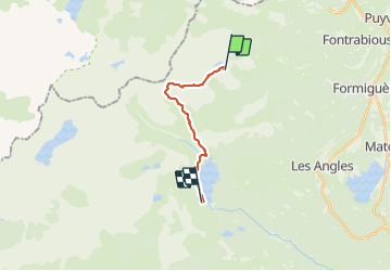

Length
12.4 km

Max alt
2795 m

Uphill gradient
691 m
Km-Effort
22 km

Min alt
2021 m

Downhill gradient
896 m
Boucle
No
Creation date :
2021-09-17 07:04:18.281
Updated on :
2021-09-17 13:38:41.058
6h33
Difficulty : Very difficult

FREE GPS app for hiking
 SityTrail
IGN / Geographical institutes
SityTrail Plus
The world is yours!
About
Trail Walking of 12.4 km to be discovered at Occitania, Pyrénées-Orientales, Formiguères. This trail is proposed by Frings.
Positioning
Country:
France
Region :
Occitania
Department/Province :
Pyrénées-Orientales
Municipality :
Formiguères
Location:
Unknown
Start:(Dec)
Start:(UTM)
418901 ; 4719306 (31T) N.
Comments