


presqu'île de Giens ouest

Patrick Lemaire
User
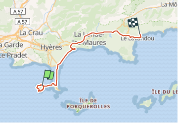

Length
42 km

Max alt
110 m

Uphill gradient
555 m
Km-Effort
50 km

Min alt
-2 m

Downhill gradient
550 m
Boucle
No
Creation date :
2021-09-17 07:42:03.336
Updated on :
2021-09-17 14:51:36.726
7h08
Difficulty : Very difficult

FREE GPS app for hiking
 SityTrail
IGN / Geographical institutes
SityTrail Plus
The world is yours!
About
Trail Walking of 42 km to be discovered at Provence-Alpes-Côte d'Azur, Var, Hyères. This trail is proposed by Patrick Lemaire.
Positioning
Country:
France
Region :
Provence-Alpes-Côte d'Azur
Department/Province :
Var
Municipality :
Hyères
Location:
Unknown
Start:(Dec)
Start:(UTM)
264337 ; 4769342 (32T) N.
Comments