


marron 17/09/21
© OpenStreetMap contributors


3h37
Difficulty : Medium


Length
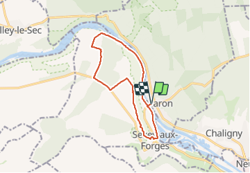
11.9 km
Max alt
346 m
Uphill gradient
189 m
Km-Effort
14.5 km
Min alt
210 m
Downhill gradient
191 m
Boucle
Yes
Creation date :
2021-09-17 11:47:07.548
Updated on :
2021-09-17 15:25:12.934
3h37
Difficulty : Medium
FREE GPS app for hiking
 SityTrail
IGN / Geographical institutes
SityTrail Plus
The world is yours!
About
Trail Walking of 11.9 km to be discovered at Grand Est, Meurthe-et-Moselle, Maron. This trail is proposed by jerome-dupont@laposte.net.
Description
Panorama sur la vallée de la moselle
Positioning
Country:
France
Region :
Grand Est
Department/Province :
Meurthe-et-Moselle
Municipality :
Maron
Location:
Unknown
Start:(Dec)
Start:(UTM)
282265 ; 5391110 (32U) N.
Comments