


Forcalquier

PhilippeC54
User

Length
47 km

Max alt
725 m

Uphill gradient
896 m
Km-Effort
59 km

Min alt
396 m

Downhill gradient
901 m
Boucle
Yes
Creation date :
2021-09-18 07:16:29.802
Updated on :
2021-09-18 13:36:39.242
2h57
Difficulty : Medium

FREE GPS app for hiking
 SityTrail
IGN / Geographical institutes
SityTrail Plus
The world is yours!
About
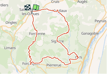
Trail Road bike of 47 km to be discovered at Provence-Alpes-Côte d'Azur, Alpes-de-Haute-Provence, Saint-Étienne-les-Orgues. This trail is proposed by PhilippeC54.
Positioning
Country:
France
Region :
Provence-Alpes-Côte d'Azur
Department/Province :
Alpes-de-Haute-Provence
Municipality :
Saint-Étienne-les-Orgues
Location:
Unknown
Start:(Dec)
Start:(UTM)
722910 ; 4880182 (31T) N.
Comments