


Recee Transarden-3

guy284
User
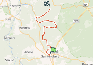

Length
20 km

Max alt
559 m

Uphill gradient
583 m
Km-Effort
27 km

Min alt
296 m

Downhill gradient
498 m
Boucle
No
Creation date :
2019-12-13 21:31:43.151
Updated on :
2021-09-18 18:20:44.206
7h38
Difficulty : Difficult

FREE GPS app for hiking
 SityTrail
IGN / Geographical institutes
SityTrail Plus
The world is yours!
About
Trail Walking of 20 km to be discovered at Wallonia, Luxembourg, Saint-Hubert. This trail is proposed by guy284.
Description
Saint Hubert - Nassogne
Positioning
Country:
Belgium
Region :
Wallonia
Department/Province :
Luxembourg
Municipality :
Saint-Hubert
Location:
Unknown
Start:(Dec)
Start:(UTM)
669981 ; 5544223 (31U) N.
Comments