


dimanche 19 sep tomtom7

Titinechris
User
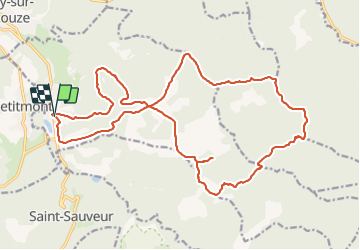

Length
23 km

Max alt
607 m

Uphill gradient
777 m
Km-Effort
33 km

Min alt
317 m

Downhill gradient
772 m
Boucle
Yes
Creation date :
2021-09-19 06:06:48.61
Updated on :
2021-09-19 11:13:52.628
3h59
Difficulty : Easy

FREE GPS app for hiking
 SityTrail
IGN / Geographical institutes
SityTrail Plus
The world is yours!
About
Trail Trail of 23 km to be discovered at Grand Est, Meurthe-et-Moselle, Val-et-Châtillon. This trail is proposed by Titinechris.
Positioning
Country:
France
Region :
Grand Est
Department/Province :
Meurthe-et-Moselle
Municipality :
Val-et-Châtillon
Location:
Unknown
Start:(Dec)
Start:(UTM)
350018 ; 5380166 (32U) N.
Comments