


Recee transarden-2

guy284
User
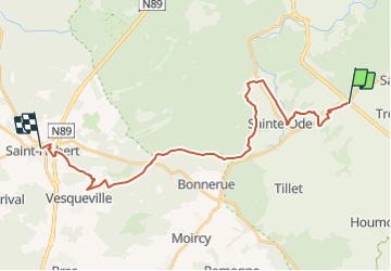

Length
24 km

Max alt
565 m

Uphill gradient
495 m
Km-Effort
31 km

Min alt
364 m

Downhill gradient
503 m
Boucle
No
Creation date :
2021-09-11 17:10:14.248
Updated on :
2021-09-20 19:01:07.947
4h43
Difficulty : Difficult

FREE GPS app for hiking
 SityTrail
IGN / Geographical institutes
SityTrail Plus
The world is yours!
About
Trail Walking of 24 km to be discovered at Wallonia, Luxembourg, Sainte-Ode. This trail is proposed by guy284.
Positioning
Country:
Belgium
Region :
Wallonia
Department/Province :
Luxembourg
Municipality :
Sainte-Ode
Location:
Unknown
Start:(Dec)
Start:(UTM)
683855 ; 5546735 (31U) N.
Comments
Belle rando