


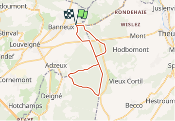
Banneux Fagne St Remacle

Delhezpy
User

Length
11.2 km

Max alt
356 m

Uphill gradient
202 m
Km-Effort
13.9 km

Min alt
253 m

Downhill gradient
202 m
Boucle
Yes
Creation date :
2021-09-21 15:03:41.958
Updated on :
2021-09-21 15:05:17.496
3h08
Difficulty : Difficult

FREE GPS app for hiking
 SityTrail
IGN / Geographical institutes
SityTrail Plus
The world is yours!
About
Trail Walking of 11.2 km to be discovered at Wallonia, Liège, Sprimont. This trail is proposed by Delhezpy.
Positioning
Country:
Belgium
Region :
Wallonia
Department/Province :
Liège
Municipality :
Sprimont
Location:
Louveigné
Start:(Dec)
Start:(UTM)
694644 ; 5602180 (31U) N.
Comments