


COLOMBIER Aillon le vieux

JacouBrijou
User
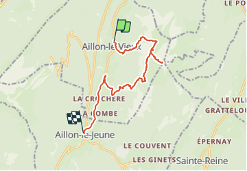

Length
12.9 km

Max alt
2030 m

Uphill gradient
1139 m
Km-Effort
28 km

Min alt
886 m

Downhill gradient
1166 m
Boucle
No
Creation date :
2021-09-21 06:34:55.129
Updated on :
2021-09-21 20:29:18.544
7h26
Difficulty : Very difficult

FREE GPS app for hiking
 SityTrail
IGN / Geographical institutes
SityTrail Plus
The world is yours!
About
Trail Walking of 12.9 km to be discovered at Auvergne-Rhône-Alpes, Savoy, Aillon-le-Vieux. This trail is proposed by JacouBrijou.
Description
Départ difficile.
Magnifique point de vue au Colombier
Positioning
Country:
France
Region :
Auvergne-Rhône-Alpes
Department/Province :
Savoy
Municipality :
Aillon-le-Vieux
Location:
Unknown
Start:(Dec)
Start:(UTM)
273652 ; 5059472 (32T) N.
Comments