


Le chemin de la Ramille

c.chehere
User

Length
8.2 km

Max alt
960 m

Uphill gradient
294 m
Km-Effort
12.2 km

Min alt
717 m

Downhill gradient
294 m
Boucle
Yes
Creation date :
2021-09-22 05:57:04.231
Updated on :
2021-09-22 09:20:27.927
3h02
Difficulty : Easy

FREE GPS app for hiking
 SityTrail
IGN / Geographical institutes
SityTrail Plus
The world is yours!
About
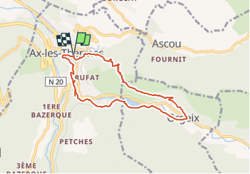
Trail Walking of 8.2 km to be discovered at Occitania, Ariège, Ax-les-Thermes. This trail is proposed by c.chehere.
Description
Très belle balade en partie balisée
Photos


Positioning
Country:
France
Region :
Occitania
Department/Province :
Ariège
Municipality :
Ax-les-Thermes
Location:
Unknown
Start:(Dec)
Start:(UTM)
405000 ; 4730259 (31T) N.
Comments