


forêt et lacs

dedejojo
User

Length
26 km

Max alt
135 m

Uphill gradient
266 m
Km-Effort
30 km

Min alt
5 m

Downhill gradient
266 m
Boucle
Yes
Creation date :
2021-09-22 09:18:02.113
Updated on :
2021-09-22 09:20:05.825
6h42
Difficulty : Very difficult

FREE GPS app for hiking
 SityTrail
IGN / Geographical institutes
SityTrail Plus
The world is yours!
About
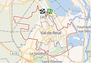
Trail Walking of 26 km to be discovered at Normandy, Eure, Léry. This trail is proposed by dedejojo.
Positioning
Country:
France
Region :
Normandy
Department/Province :
Eure
Municipality :
Léry
Location:
Unknown
Start:(Dec)
Start:(UTM)
369604 ; 5460775 (31U) N.
Comments