


Compostelle étape 3

maginot
User

Length
32 km

Max alt
348 m

Uphill gradient
491 m
Km-Effort
38 km

Min alt
188 m

Downhill gradient
424 m
Boucle
No
Creation date :
2021-09-22 06:57:51.0
Updated on :
2021-09-22 16:42:50.658
8h00
Difficulty : Difficult

FREE GPS app for hiking
 SityTrail
IGN / Geographical institutes
SityTrail Plus
The world is yours!
About
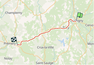
Trail Walking of 32 km to be discovered at Bourgogne-Franche-Comté, Nièvre, Corbigny. This trail is proposed by maginot.
Description
Départ de Corbigny à 8h30
Pour Pemery
Début parcours,maintenant sur la fin beaucoup de route Dangereux et pas agréable
Positioning
Country:
France
Region :
Bourgogne-Franche-Comté
Department/Province :
Nièvre
Municipality :
Corbigny
Location:
Unknown
Start:(Dec)
Start:(UTM)
551622 ; 5233882 (31T) N.
Comments