


col bramousse

noelphil
User
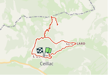

Length
10.5 km

Max alt
2345 m

Uphill gradient
690 m
Km-Effort
19.7 km

Min alt
1662 m

Downhill gradient
692 m
Boucle
Yes
Creation date :
2021-09-24 09:12:17.499
Updated on :
2021-09-24 15:27:31.847
6h14
Difficulty : Very difficult

FREE GPS app for hiking
 SityTrail
IGN / Geographical institutes
SityTrail Plus
The world is yours!
About
Trail Walking of 10.5 km to be discovered at Provence-Alpes-Côte d'Azur, Hautes-Alpes, Ceillac. This trail is proposed by noelphil.
Description
Super agréable
Positioning
Country:
France
Region :
Provence-Alpes-Côte d'Azur
Department/Province :
Hautes-Alpes
Municipality :
Ceillac
Location:
Unknown
Start:(Dec)
Start:(UTM)
323769 ; 4948816 (32T) N.
Comments