


Compostelle etape 5

maginot
User

Length
27 km

Max alt
254 m

Uphill gradient
239 m
Km-Effort
30 km

Min alt
164 m

Downhill gradient
265 m
Boucle
No
Creation date :
2021-09-24 06:13:33.0
Updated on :
2021-09-24 18:36:27.218
8h01
Difficulty : Medium

FREE GPS app for hiking
 SityTrail
IGN / Geographical institutes
SityTrail Plus
The world is yours!
About
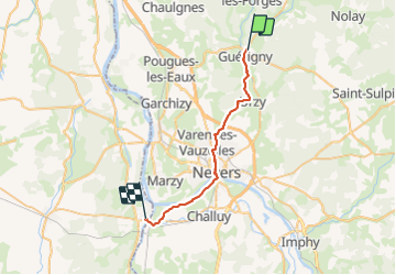
Trail Walking of 27 km to be discovered at Bourgogne-Franche-Comté, Nièvre, Guérigny. This trail is proposed by maginot.
Description
Départ de Guerigny 8 h
Encore beaucoup de route asphalte
Pris le Gr 654 plus agréable mais route aussi
passage de la Loire à Nevers
Puis L Allier et canal de bourgogne
Positioning
Country:
France
Region :
Bourgogne-Franche-Comté
Department/Province :
Nièvre
Municipality :
Guérigny
Location:
Unknown
Start:(Dec)
Start:(UTM)
514962 ; 5215402 (31T) N.
Comments