


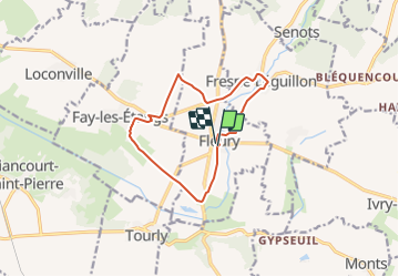
Fleury

Djaie60
User

Length
10.7 km

Max alt
99 m

Uphill gradient
64 m
Km-Effort
11.5 km

Min alt
70 m

Downhill gradient
62 m
Boucle
Yes
Creation date :
2021-09-24 21:40:31.0
Updated on :
2021-10-03 17:36:24.265
2h36
Difficulty : Easy

FREE GPS app for hiking
 SityTrail
IGN / Geographical institutes
SityTrail Plus
The world is yours!
About
Trail On foot of 10.7 km to be discovered at Hauts-de-France, Oise, Fleury. This trail is proposed by Djaie60.
Positioning
Country:
France
Region :
Hauts-de-France
Department/Province :
Oise
Municipality :
Fleury
Location:
Unknown
Start:(Dec)
Start:(UTM)
424959 ; 5454807 (31U) N.
Comments