


Mellecey La Vallée des Vaux page 48

grasgilbert
User
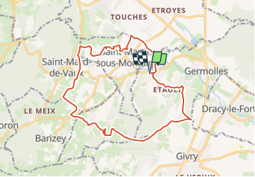

Length
17.8 km

Max alt
416 m

Uphill gradient
408 m
Km-Effort
23 km

Min alt
209 m

Downhill gradient
408 m
Boucle
Yes
Creation date :
2021-09-27 13:53:28.635
Updated on :
2023-09-14 15:13:11.97
5h17
Difficulty : Very difficult

FREE GPS app for hiking
 SityTrail
IGN / Geographical institutes
SityTrail Plus
The world is yours!
About
Trail Walking of 17.8 km to be discovered at Bourgogne-Franche-Comté, Saône-et-Loire, Mellecey. This trail is proposed by grasgilbert.
Description
si le circuit est trop long descendre directement sur mellecey depuis la croix sur le GR 7

Positioning
Country:
France
Region :
Bourgogne-Franche-Comté
Department/Province :
Saône-et-Loire
Municipality :
Mellecey
Location:
Unknown
Start:(Dec)
Start:(UTM)
631614 ; 5185540 (31T) N.
Comments