


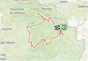
Mont Ventoux par Sault et gorges de la Nesque

PhilippeC54
User

Length
89 km

Max alt
1910 m

Uphill gradient
2413 m
Km-Effort
122 km

Min alt
291 m

Downhill gradient
2414 m
Boucle
Yes
Creation date :
2021-09-27 07:31:16.037
Updated on :
2021-09-28 15:44:23.84
4h59
Difficulty : Difficult

FREE GPS app for hiking
 SityTrail
IGN / Geographical institutes
SityTrail Plus
The world is yours!
About
Trail Road bike of 89 km to be discovered at Provence-Alpes-Côte d'Azur, Vaucluse, Sault. This trail is proposed by PhilippeC54.
Positioning
Country:
France
Region :
Provence-Alpes-Côte d'Azur
Department/Province :
Vaucluse
Municipality :
Sault
Location:
Unknown
Start:(Dec)
Start:(UTM)
693168 ; 4885165 (31T) N.
Comments