


Compostelle etape 8

maginot
User

Length
14.4 km

Max alt
198 m

Uphill gradient
43 m
Km-Effort
15.1 km

Min alt
154 m

Downhill gradient
86 m
Boucle
No
Creation date :
2021-09-27 07:41:19.0
Updated on :
2021-09-27 17:53:18.287
7h45
Difficulty : Easy

FREE GPS app for hiking
 SityTrail
IGN / Geographical institutes
SityTrail Plus
The world is yours!
About
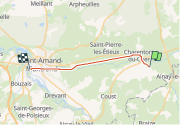
Trail Walking of 14.4 km to be discovered at Centre-Loire Valley, Cher, Charenton-du-Cher. This trail is proposed by maginot.
Description
Départ 8 h
Très beau village et chemin sympa
Arrive dans cher
Canal et canal
Arrivé à St Amand Montond
Positioning
Country:
France
Region :
Centre-Loire Valley
Department/Province :
Cher
Municipality :
Charenton-du-Cher
Location:
Unknown
Start:(Dec)
Start:(UTM)
473477 ; 5174111 (31T) N.
Comments