


Prissé

janussity
User

Length
7.9 km

Max alt
323 m

Uphill gradient
178 m
Km-Effort
10.3 km

Min alt
210 m

Downhill gradient
178 m
Boucle
Yes
Creation date :
2021-09-28 13:26:03.382
Updated on :
2021-09-28 13:30:44.851
2h20
Difficulty : Medium

FREE GPS app for hiking
 SityTrail
IGN / Geographical institutes
SityTrail Plus
The world is yours!
About
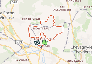
Trail Walking of 7.9 km to be discovered at Bourgogne-Franche-Comté, Saône-et-Loire, Prissé. This trail is proposed by janussity.
Description
Départ parking des 2 roches.
Pavillon des Girondins
Montagne de Montceau
Somméré
Carrière de la Lie
Château de Montceau.
Positioning
Country:
France
Region :
Bourgogne-Franche-Comté
Department/Province :
Saône-et-Loire
Municipality :
Prissé
Location:
Unknown
Start:(Dec)
Start:(UTM)
634191 ; 5132396 (31T) N.
Comments