


Le chemin de Quère

c.chehere
User

Length
8.2 km

Max alt
846 m

Uphill gradient
200 m
Km-Effort
10.9 km

Min alt
668 m

Downhill gradient
199 m
Boucle
Yes
Creation date :
2021-09-29 05:58:58.436
Updated on :
2021-09-29 09:04:38.322
2h46
Difficulty : Easy

FREE GPS app for hiking
 SityTrail
IGN / Geographical institutes
SityTrail Plus
The world is yours!
About
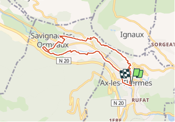
Trail Walking of 8.2 km to be discovered at Occitania, Ariège, Ax-les-Thermes. This trail is proposed by c.chehere.
Description
Petite balade entre Ax les thermes et Savignac. Bruit de la RN 20 et 2020 très présent sur une grande partie de la balade
Photos


Positioning
Country:
France
Region :
Occitania
Department/Province :
Ariège
Municipality :
Ax-les-Thermes
Location:
Unknown
Start:(Dec)
Start:(UTM)
404999 ; 4730257 (31T) N.
Comments