


11414152-GAV non balisé sens AH

denel
User
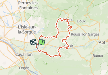

Length
70 km

Max alt
591 m

Uphill gradient
1318 m
Km-Effort
88 km

Min alt
85 m

Downhill gradient
1321 m
Boucle
Yes
Creation date :
2021-09-29 12:10:36.635
Updated on :
2022-03-04 20:06:08.093
5h18
Difficulty : Very difficult

FREE GPS app for hiking
 SityTrail
IGN / Geographical institutes
SityTrail Plus
The world is yours!
About
Trail Road bike of 70 km to be discovered at Provence-Alpes-Côte d'Azur, Vaucluse, Robion. This trail is proposed by denel.
Description
Rando découverte des villages du Lubéron
Positioning
Country:
France
Region :
Provence-Alpes-Côte d'Azur
Department/Province :
Vaucluse
Municipality :
Robion
Location:
Unknown
Start:(Dec)
Start:(UTM)
668960 ; 4857751 (31T) N.
Comments