


Randonnée chemin des bâche

coulon
User
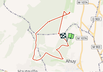

Length
8.4 km

Max alt
395 m

Uphill gradient
143 m
Km-Effort
10.3 km

Min alt
298 m

Downhill gradient
145 m
Boucle
Yes
Creation date :
2021-09-30 12:20:11.0
Updated on :
2021-09-30 14:38:30.477
2h17
Difficulty : Unknown

FREE GPS app for hiking
 SityTrail
IGN / Geographical institutes
SityTrail Plus
The world is yours!
About
Trail Walking of 8.4 km to be discovered at Bourgogne-Franche-Comté, Côte-d'Or, Ahuy. This trail is proposed by coulon.
Description
Départ parking
Positioning
Country:
France
Region :
Bourgogne-Franche-Comté
Department/Province :
Côte-d'Or
Municipality :
Ahuy
Location:
Unknown
Start:(Dec)
Start:(UTM)
652281 ; 5249124 (31T) N.
Comments