


Cluny la randonnée des Moines 2 page 145

grasgilbert
User
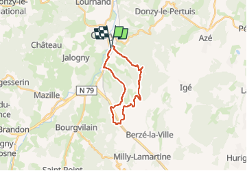

Length
14.7 km

Max alt
565 m

Uphill gradient
457 m
Km-Effort
21 km

Min alt
244 m

Downhill gradient
458 m
Boucle
Yes
Creation date :
2021-09-30 07:33:18.396
Updated on :
2025-06-24 17:29:28.121
4h43
Difficulty : Very difficult

FREE GPS app for hiking
 SityTrail
IGN / Geographical institutes
SityTrail Plus
The world is yours!
About
Trail Walking of 14.7 km to be discovered at Bourgogne-Franche-Comté, Saône-et-Loire, Cluny. This trail is proposed by grasgilbert.
Photos

Positioning
Country:
France
Region :
Bourgogne-Franche-Comté
Department/Province :
Saône-et-Loire
Municipality :
Cluny
Location:
Unknown
Start:(Dec)
Start:(UTM)
628059 ; 5142600 (31T) N.
Comments