


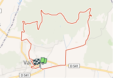
Valaurie 7km

thonyc
User GUIDE

Length
6.5 km

Max alt
204 m

Uphill gradient
130 m
Km-Effort
8.2 km

Min alt
111 m

Downhill gradient
138 m
Boucle
Yes
Creation date :
2021-10-01 07:29:56.589
Updated on :
2021-10-01 07:34:14.71
2h11
Difficulty : Medium

FREE GPS app for hiking
 SityTrail
IGN / Geographical institutes
SityTrail Plus
The world is yours!
About
Trail Walking of 6.5 km to be discovered at Auvergne-Rhône-Alpes, Drôme, Valaurie. This trail is proposed by thonyc.
Positioning
Country:
France
Region :
Auvergne-Rhône-Alpes
Department/Province :
Drôme
Municipality :
Valaurie
Location:
Unknown
Start:(Dec)
Start:(UTM)
644523 ; 4920297 (31T) N.
Comments