


13767704-JVB 15 km

jeanmarcMasson
User GUIDE
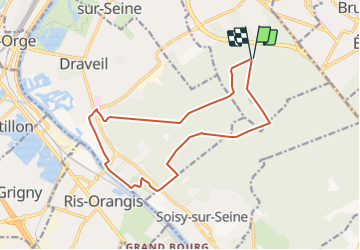

Length
14.6 km

Max alt
95 m

Uphill gradient
128 m
Km-Effort
16.3 km

Min alt
27 m

Downhill gradient
128 m
Boucle
Yes
Creation date :
2021-10-01 16:23:28.488
Updated on :
2021-10-01 16:24:42.626
3h42
Difficulty : Difficult

FREE GPS app for hiking
 SityTrail
IGN / Geographical institutes
SityTrail Plus
The world is yours!
About
Trail Walking of 14.6 km to be discovered at Ile-de-France, Essonne, Montgeron. This trail is proposed by jeanmarcMasson.
Positioning
Country:
France
Region :
Ile-de-France
Department/Province :
Essonne
Municipality :
Montgeron
Location:
Unknown
Start:(Dec)
Start:(UTM)
460741 ; 5392729 (31U) N.
Comments