


Guigne Calais

Morelli
User

Length
22 km

Max alt
15 m

Uphill gradient
96 m
Km-Effort
24 km

Min alt
-2 m

Downhill gradient
96 m
Boucle
No
Creation date :
2021-10-02 07:06:44.189
Updated on :
2021-10-02 14:06:15.5
5h42
Difficulty : Difficult

FREE GPS app for hiking
 SityTrail
IGN / Geographical institutes
SityTrail Plus
The world is yours!
About
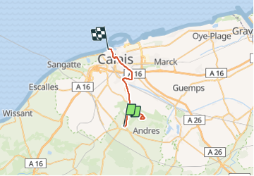
Trail Walking of 22 km to be discovered at Hauts-de-France, Pas-de-Calais, Guînes. This trail is proposed by Morelli.
Positioning
Country:
France
Region :
Hauts-de-France
Department/Province :
Pas-de-Calais
Municipality :
Guînes
Location:
Unknown
Start:(Dec)
Start:(UTM)
420505 ; 5635897 (31U) N.
Comments