


Compostelle etape 13

maginot
User
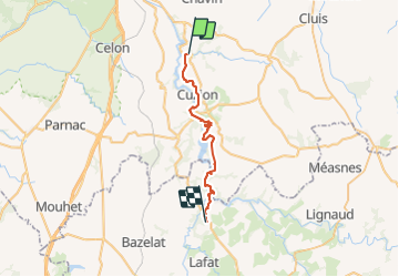

Length
29 km

Max alt
339 m

Uphill gradient
766 m
Km-Effort
39 km

Min alt
139 m

Downhill gradient
571 m
Boucle
No
Creation date :
2021-10-02 07:03:24.0
Updated on :
2021-10-02 21:11:28.956
9h58
Difficulty : Difficult

FREE GPS app for hiking
 SityTrail
IGN / Geographical institutes
SityTrail Plus
The world is yours!
About
Trail Walking of 29 km to be discovered at Centre-Loire Valley, Indre, Gargilesse-Dampierre. This trail is proposed by maginot.
Description
Super étape beau chemin par le Gr 654 point de vu exceptionnel sur la Creuse
Photos


Positioning
Country:
France
Region :
Centre-Loire Valley
Department/Province :
Indre
Municipality :
Gargilesse-Dampierre
Location:
Unknown
Start:(Dec)
Start:(UTM)
392298 ; 5152013 (31T) N.
Comments