


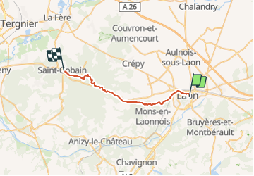
Randonnée Laon Saint Gobain

BrassensJC
User

Length
24 km

Max alt
208 m

Uphill gradient
437 m
Km-Effort
30 km

Min alt
67 m

Downhill gradient
431 m
Boucle
No
Creation date :
2021-10-05 08:29:49.534
Updated on :
2021-10-05 08:39:56.026
6h52
Difficulty : Very difficult

FREE GPS app for hiking
 SityTrail
IGN / Geographical institutes
SityTrail Plus
The world is yours!
About
Trail Walking of 24 km to be discovered at Hauts-de-France, Aisne, Laon. This trail is proposed by BrassensJC.
Positioning
Country:
France
Region :
Hauts-de-France
Department/Province :
Aisne
Municipality :
Laon
Location:
Unknown
Start:(Dec)
Start:(UTM)
545161 ; 5490185 (31U) N.
Comments