


marron-05/10/21
© OpenStreetMap contributors


2h49
Difficulty : Difficult


Length
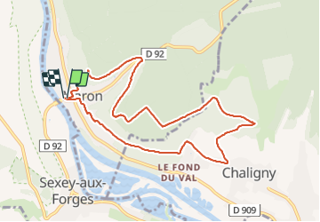
9.2 km
Max alt
380 m
Uphill gradient
196 m
Km-Effort
11.8 km
Min alt
221 m
Downhill gradient
200 m
Boucle
Yes
Creation date :
2021-10-05 12:00:23.087
Updated on :
2021-10-05 15:31:33.549
2h49
Difficulty : Difficult
FREE GPS app for hiking
 SityTrail
IGN / Geographical institutes
SityTrail Plus
The world is yours!
About
Trail Walking of 9.2 km to be discovered at Grand Est, Meurthe-et-Moselle, Maron. This trail is proposed by jerome-dupont@laposte.net.
Description
depart direct.falaises biffurque vers chaligny et retour par mazagran et F2 du caf
Positioning
Country:
France
Region :
Grand Est
Department/Province :
Meurthe-et-Moselle
Municipality :
Maron
Location:
Unknown
Start:(Dec)
Start:(UTM)
282311 ; 5391114 (32U) N.
Comments