


matton

Claude Luchetta
User
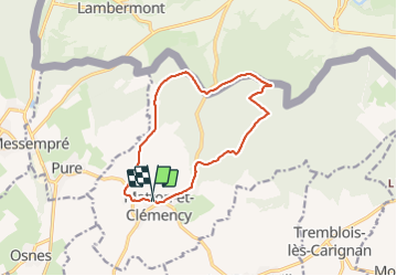

Length
11.4 km

Max alt
301 m

Uphill gradient
211 m
Km-Effort
14.3 km

Min alt
185 m

Downhill gradient
226 m
Boucle
Yes
Creation date :
2021-10-06 07:09:09.494
Updated on :
2021-10-06 11:46:36.938
2h32
Difficulty : Difficult

FREE GPS app for hiking
 SityTrail
IGN / Geographical institutes
SityTrail Plus
The world is yours!
About
Trail Walking of 11.4 km to be discovered at Grand Est, Ardennes, Matton-et-Clémency. This trail is proposed by Claude Luchetta.
Description
rando
Positioning
Country:
France
Region :
Grand Est
Department/Province :
Ardennes
Municipality :
Matton-et-Clémency
Location:
Unknown
Start:(Dec)
Start:(UTM)
658801 ; 5503839 (31U) N.
Comments