


Rando Maulevrier - La Moine 11km

jeanmarcMasson
User GUIDE
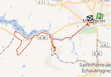

Length
12.7 km

Max alt
150 m

Uphill gradient
169 m
Km-Effort
15 km

Min alt
102 m

Downhill gradient
170 m
Boucle
Yes
Creation date :
2021-10-06 08:57:28.37
Updated on :
2021-10-06 13:26:17.257
3h07
Difficulty : Difficult

FREE GPS app for hiking
 SityTrail
IGN / Geographical institutes
SityTrail Plus
The world is yours!
About
Trail Walking of 12.7 km to be discovered at Pays de la Loire, Maine-et-Loire, Maulévrier. This trail is proposed by jeanmarcMasson.
Positioning
Country:
France
Region :
Pays de la Loire
Department/Province :
Maine-et-Loire
Municipality :
Maulévrier
Location:
Unknown
Start:(Dec)
Start:(UTM)
671461 ; 5208449 (30T) N.
Comments